
The hamlet of Holt Street, sometimes called Old Street, lies some half of a mile or so to the south-east of Nonington church and derives its name from holt, the Old English (OE) name for a thicket or wood. Holt Street was part of the Fredville sub-division of the knight’s fee and manor of Essewelle, which was divided into the manors of Esole and Fredville. The Holt Street area was once heavily wooded, adjoining Holt Street to the south-west is Acol or Ackholt, meaning an oak thicket or wood; to the south is Oxenden, or Oxney, Wood; and to the east is Hangers, sometimes Hanging or Hangman’s, Hill which derives from the OE hangra: a wooded slope or hillside.
Old documents and censuses often refer to the lower part of Holt Street as The Drove, from the OE draf, a cattle road.
Archbishop Pecham’s survey of 1283-85 recorded Simon of Holestreete and Roger of Holestreete as holding 2 acres 1 virgate and 1 ½ acres respectively in adjoining Ackholt and there is also a reference to a Robert Hollestrete in a document of 1290. There is also a reference to Holt Street in a 1309 grant by John, the son of Stephen de Akholte to John, the son of Thomas de Akholte of “unum molendinum ventifluim (venti fluim) in paroch de Nonyngton juxta Holestrete in ter(re) de Freydvile” [“one wind mill in the parish of Nonyngton, near Holestrete [Holt Street] on Freydviles land [the manor of Fredville”].
The mill referred to is the “lost” Holt Street windmill.
When the parish of Nonington was founded in 1282 the foundation deed referred to the hamlet of Freydeville [Fredville], this would appear to be Holt Street, the main settlement for the Fredville manor part of knight’s fee of Essewelle. Before the Boys family built themselves a new mansion house in the present Fredville Park in the early 1500’s the site of any previous Fredville manor house, if indeed there had been one, is unclear, and the present Holt Street farm could therefore have been the location of the Fredville manor house.
There is a reference to Holstreet in Robert Baker’s bequest in will of 1505 to the Light of Our Lady of Holstreet and to the Cross Light of Holstreet of a bushel of barley each, and the sum of 20/- (£. 1. 00) “to the buying of an antiphoner (liturgical book) for the church” .
++++++
Holt Street Estate & Farm.
Sadly, there are very few comprehensive records or references to Holt Street before the 1600’s. It is very likely that the Holt Street estate was for some time the residence of the eldest son and heir of the Fredville Boys’. The Nonington parish registers records the baptism on May 29th, 1606, of Anna, the daughter of Sir Edward Boys the Younger, with the entry referring to Sir Edward as being a gentleman of Holtestreete [Holt Street]. Two earlier baptism records make no mention of his place of residence. The present Holt Street farmhouse appears to date from around 1600, so it possible that the present house is a replacement for an earlier building by then deemed unsuitable for a gentleman of Sir Edward’s status.

Above:-Holt Street Farmhouse in the 1930’s when it was rented to Army officers from the Dover garrison. The house was built around 1600 for the Boys family of Fredville, and appears to have been used as the residence of the family’s successive eldest sons and heirs.
+++
Later in the 1600’s Holt Street was occupied by the Gay family, also Gaye and LeGay, who also held land in the Tenderden area in West Kent. When Edmund Gay, gentleman of Nonington, Kent, died in 1651 he was followed as tenant by his son, Jeremy, also Jeremiah.
During the English Civil War Jeremy took the Royalist side and suffered accordingly, his landlord, Major John Boys, had been on the opposing side. After the Restoration of King Charles II in 1660 Major Boys of Fredville was heavily in debt to various creditors and had been selling off parts of the Fredville estate for some time, and in 1670 Holt Street was conveyed to Jeremy Gay and Robert Kingsford. The Holt Street estate then consisted of:
“A capital messuage and appurtenences together with barnes stables pidgeon house and out-houses thereto belonging or thereto used to enjoy (Holt Street Farm). And all the arable lands meadows pastures down-lands and woodland thereto belonging containing 252 acres more or less at or near Holt Street in the parish of Nonington in Kent.
And all that messuage with the appurtenences and all the land meadows and pasture thereunto belonging containing 14 acres lying in or near Holt Street now or late in the occupation of ? late in occupation of George Cork/Cock or his assigns. (Cookys or Holt Street Cottage, adjacent land, and part of the land across the road on Cook’s Hill).
* And all the messuage of 4 acres of land in Nonington and in the occupation of ? Rist, widow, or her assigns
And the messuage and 3 acres of land therein enjoyed near Holt Street late in the occupation of Edward Symonds and his assigns.[Now Ingleside in Holt Street].
And the barn called Symons’s Barn and the appurtenences being in the place or yard of the messuage last before mentioned and then occupied by Edward Symonds but now of Richard Kingsford or his assigns. (Now Ingleside in Holt Street, the barn was demolished in 1970’s).
And the messuage or tenement and appurtenences and 3 acres of land more or less thereto butting or adjoining aforesaid at or near Holt Street in the occupation of Thomas Packton or his assigns.
*And the messuage and 4 acres of land more or less being in Nonington also in the occupation of Thomas Packton or his Assigns (believed to be the present Butter Street Cottage).
*And the messuage or tenement and 4 acres of land more or less thereto belonging or the same used occupied or enjoyed situated in Womenswold occupied by John Morris.
+And 2 pieces or parcells of arable land called Chapman’s Close and thereof 8 acres or by what other name the same are called containing 20 acres in Nonington and in the occupation of Richard Kingsford or his assigns.(Chapman’s Close: the embanked field at the top of Chapman’s Hill, south side).
And the cottage or tenement and appurtenences and 1 acre of land more or less ( -?- ) near Holt Street within the lands occupied of George Cork/Cock and then or late of Samuel Turvey and his assigns [On the Holt Street cross-roads, the cottage can be seen to the left of the road in the Cookys photograph above. It was demolished around 1910 and the houses built on the land became known as Johnston’s Terrace. A Mr. Johnston had been the tenant of the cottage prior to its demolition ].
*And a cottage or tenement and 1 acre of land by estimation in Nonington in the tenure of Samuel Browning and his assigns.
*And a cottage or tenement and 2 acres in Nonington in the occupation of George Marsh.
*And a cottage or tenement and appurtenences and 1 acre of land by estimation thereto belonging in Nonington and in the occupation of Wm Fagg and his assigns.
~And that wood and woodland called -?- Wood [Broome Hill Wood?] containing 13 acres and one half in Nonington in the occupation of Jeremy Gay”.
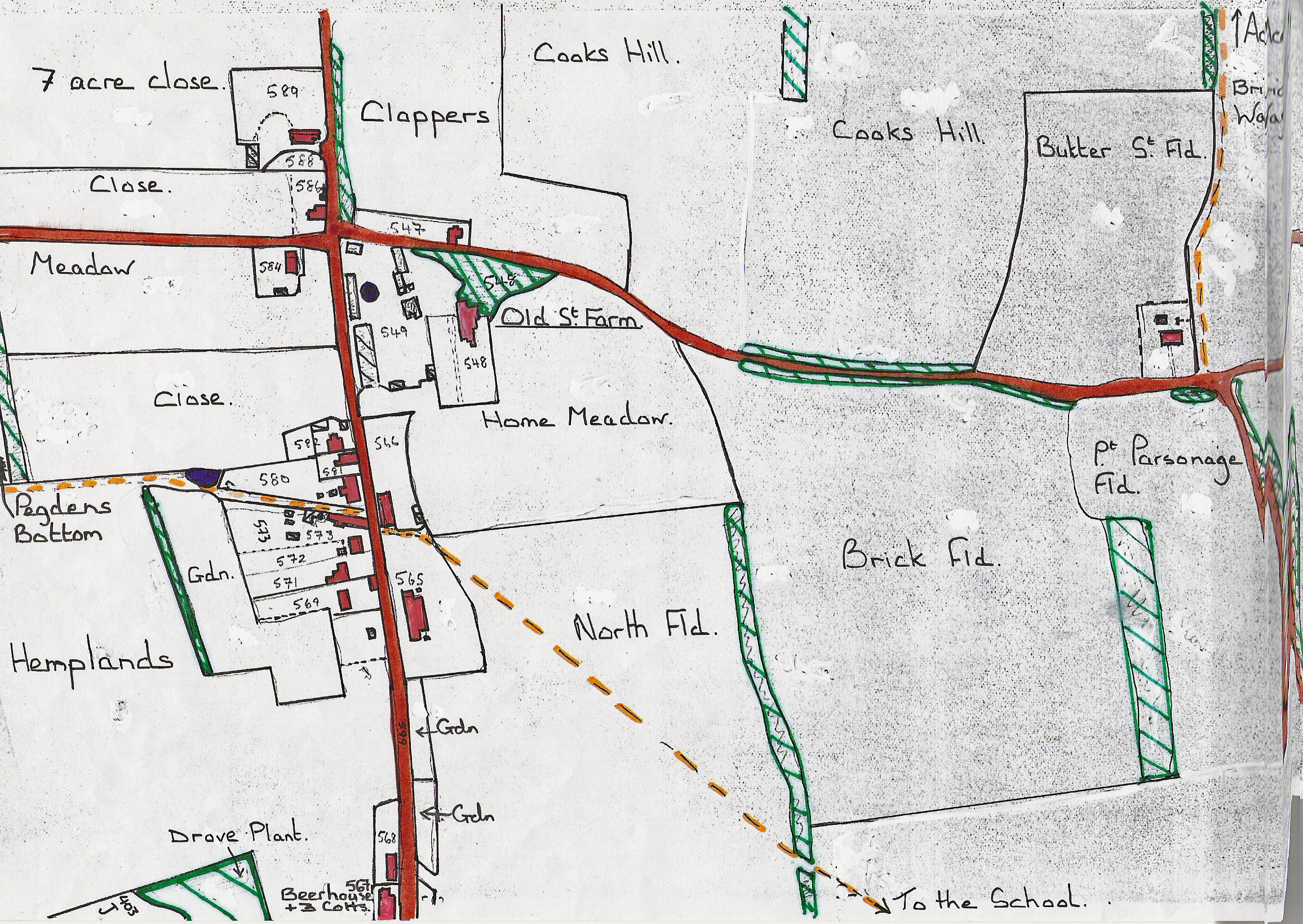
Above:-Holt Street Farm & surroundings. A sketch map taken from the Nonington 1859 Poor Law Commissioners survey map. The cottages and their plots would have changed little between the time of the above document and the surveying of the map.
+++
Jeremy Gay of Holt Street’s son, also Jeremy, was the subject of two court orders in 1672. Presumably Jeremy senior, his father, had died and Jeremy junior appears to have had got into debt as in January 1671 (1672) an ” Order after reciting the outlawry of Jeremy Gay of Nonington, Kent, and the seizure, 29 Jan., 1671–2, of his lands therein described at Tenterden on a motion on behalf of Edward and Samuel Curteis that on their giving security to abide the order of the court all further proceedings against the said lands be stayed” was issued. Edward and Samuel were the sons of Edward Curteis, senior, and Dorothy, the sister of Jeremy Gay, junior, and therefore Jeremy juniors first cousins. Edward Curteis, senior, had been Mayor of Tenterden in 1663, and Edward junior was to follow his father as mayor some years later.
Later in the year an Order of the Court at Dover of 6th June, 1672, concerned the seizure of the property of Jeremy Gay, junior, of Tenterden and Nonington, Kent, for debt and his being made an outlaw.
After the court order, the Kingsford’s took over as sole owners of Holt Street.
+++
Robert Kingsford, the joint signatory of the 1670 conveyance of Fredville died in the early 1670’s and in 1676 Holt Street farm was rented to Fulke Rose, a wealthy Jamaica merchant by Richard Kingsford, Robert’s son and heir. The rented property consisted of “A messuage or mansion house and all barns stables pigeon house and outhouses edifices and buildings gardens orchards and yards. 258 acres of land wood and pasture occupied by Rich. Kingsford”.
Rose appears to have bought Holt Street by 1684 and in that year he was recorded as occupying the Holt Street estate then consisting of 12 messuages and gardens, 220 acres of land, 100 acres of pastures and 15 acres of woodland in Nonington & Womenswold parishes.
Another contemporary sale document records the sale of “about four acres and appurtenences lying in Nonnington aforesaid abutting to a wood called Coney Wood to the west, and the lands of Fulke Rose towards the north and south”. Coney Wood is on the old Nonington parish southern boundary with Womenswold parish to the west of the Snowdown to Woolege Village road.
Fulke Rose’s will of 1693 stated “I will give and bequeath unto my youngest daughter Mary Rose and her heires for ever Nonnington Farm near Canterbury in the county of Kent now or lately in the tenure and occupation of [blank sic-unfortunately the tenant is not recorded]. Mary inherited Nonnington Farm when her father died in 1694, and the Holt Street estate continued to be refedrred to as Nonnington Farm into the early 1700’s.
However, nothing is forever, and in 1731 Thomas Sharpe owned the 252 acre Holt Street Estate with John Cox, Robert Cussons, William Cork, Thomas Attwood, William Beane, Valentine Beane and Widow Pilcher as tenants. Nine years later Holt Street Farm was in the ownership of Thomas Green and was listed in his 1740 will as one of his assets, but the beneficiaries appear to have sold it fairly quickly as Holt Street Farm was bought by trustees of the infant Sir Brook Bridges of Goodnestone in 1754. These trustees were active purchasers of land locally in the 1750’s and 1760’s, they also bought the adjacent Acol estate in 1763. Woolege Farm and Oxney Wood were also acquired at around this time.
As a constituent part of the Manor of Fredville the Holt Street estate and hamlet had some residual feudal rights and duties attached to it, a 1710 document and the 1754 transfer deed mention amongst other things the right of frankenpledge and to court leet. The 1754 transfer states that frankenpledge concerned: ” all tenants residents and inhabitants also all other residents or commoners within the manor lordship vill and hamlet of Fredvill and St. Albans in the said manor of Kent and within the moyety or half hundred of Estray (Eastry)”. The Manor of Esole had become known as the Manor of St. Alban’s by the early 1500’s.
+++
Frankenpledge dated back to pre-Conquest times. In Anglo-Saxon society a man’s “kindred” were responsible for any offences he committed and laws of Kings Athelstan (924-940), Edgar (959-975) and Canute (1016-35) systemize the notion of collective responsibility by requiring every man to have a borh or surety. Frankenpledge had fully evolved by the reign of King William I., the Conqueror, in the North of England it was called tenmannetalle. Every freeman had to enrol in a group of ten (tithing) whose members were then bound to produce any of their number wanted by the law, for example, to give evidence or pay penalty. Twice yearly the sheriff held a ‘view to frankenpledge’ in the hundred court to ensure men were enrolled. View rights were sometimes given to individual lords or boroughs.
+++
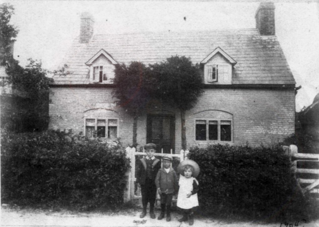
Above:-Ingleside in Holt Street, circa, 1904. The children are members of the Groombridge family who had recently taken over the tenancy of Holt Street farm. To the right is Symond’s Barn, and to the left a cottage demolished around 1910 when Ingleside was improved and extended. Both barn and cottage are mention in the 1670 lease.
+++
The Holt Street Estate, in the form of Holt Street Farm, and some of the cottages referred to in the old documents still belong to the Fredville estate. A handful of the old cottages were either improved,had the old buildings demolished and replaced, or have disappeared completely and their plots of land re-used for to build new houses during the second half of the 19th century and the first half of the 20th century. Many of the original 17th century property boundaries can be seen on the 19th century tithe and Poor Law Commissioners maps and some can still to be found on the ground to this day.
Please click here for a photographic tour of Holt Street from the late 19th century onwards
The larger part of the Holt Street estate was sold to the Plumptre family of Fredville at some time after 1814 and is still owned by them. Holt Street Farm house was used as a “gentleman’s” residence until the Second World War. The 1901 census records Henry W. Plumptre as living there, later the house was rented to officers from the Dover garrisons. The farmhouse for Holt Street Farm whilst the farmhouse was rented out was what is now Ingleside in Holt Street
Cookys farm house, the ground the village school stands on, and Chapman’s Close were not part of the sale and remained as part of the Goodnestone estate holdings after the sale.

Look in https://nonington.org.uk/parish-views/a-fredville-picture-gallery/ for pictures of the Fredville House built around 1750 to replace the original Boys Fredville house. For information on the Boys family look in https://nonington.org.uk/the-old-manors-of-nonington/the-fredville-estate/the-boys-family-at-fredville/
If anyone has pictures of the “new” Boys house that burnt in 1940, I would love to have a look. My grandmother was a Boyce, and we are descendants of those who lived at Fredville Manor.